
Thursday, May 11th, 2006 – Distance Travelled 447 miles

For the first time on my trip, I woke up in a place I had woken up in before. Two days, even if not exactly wasted, had not got me very far. I could, at least, add a “side trip” to San Francisco as a footnote in my memoirs. The room was the same, because it was the same room, the lack of on-site breakfast persisted too. Carefully tucking my camera inside my jacket, I left a $20 tip for the honest cleaner and checked out.
As I was heading north this time, I crossed the boulevard, no easy task in the already heavy traffic and rode a couple of blocks north to Manhattan Bread & Bagel (1812 N Sepulveda Blvd, Manhattan Beach, CA 90266) for an breakfast that was unusual in as much as it had no bacon. It was well done though and the waitress filled me up so many times with coffee that I was worried I might later cause a flash-flood in Death Valley.
Sadly, because of my earlier error with the camera, I had little option but to spend a lot of the morning retracing my steps of the previous day. I located the Route 5 and road up it as far as Wheeler Ridge where I branched off onto the Route 99 to Bakersfield. There was nothing in Bakersfield that I specifically wanted to see, but I chose to pass through it because it had featured in one of the Clint Eastwood movies with the Orang-Utan ! As a town, it was as clichéd as it is possible to be !
Next I headed more or less south-east on Route 58, which bore the legend, in places, stating it to be the “Bakersfield-Barstow Highway“, but, near the town of Mojave, I switched to Route 14 in a north-easterly direction and which bore the far more exciting name of the “Aerospace Highway”.

This road led, after not too great a distance, to the Red Rock Canyon State Park where I got my first taste of what was to come in terms of stark, rocky and seemingly endless desert scenery. Just before Indian Wells, there was a big signpost for Death Valley itself that led me first onto the Route 178. This bypassed a large settlement at China Lake, which appeared to be some kind of naval base and weapons testing area, before heading due east, then north. I passed a large dry lake at Searles Valley (lack of an apostrophe theirs, not mine) and rode for some miles through increasingly rocky and arid country until I came to the junction with Route 190 and then I followed the directions eastward.

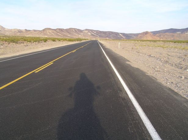
Quite where Death Valley begins, I cannot say, but my guess is that it is around that junction. What was already hot, dry, rocky and intimidating became more so in every single adjectival aspect. It was already very warm, but it felt immediately hotter and the road dropped slowly down into the bleak, lunar landscape. I could see for miles in the hot, clear air, but in all of that nothing I could not see a single moving thing.
I just stayed on the 190. There were tracks leading off of it here and there, but I am crazy, not mad. The air temperature was so high that, although I was moving, it did not cool me at all. I rode quite sedately, despite the straightness of the roads and the wonderful visibility because I was acutely aware that if I were to have even a minor mishap, I might easily die in the heat before anyone else passed by. It is easy to lapse into hyperbole when talking about Death Valley, but its sheer, shimmering immensity, particularly to European eyes, is quite staggering.

The first suggestion of any form of habitation was a few sun bleached buildings at Stovepipe Wells where a large sign announced that the road was only five feet above sea-level – to put it another way, lower than at Santa Monica on the coast. Not only that but, although it is difficult to tell in such vastness, the blacktop was clearly descending.

This fact was borne out when, just before Beatty Junction, I saw another sign stating I was then at sea-level.

It was not strikingly obvious but down and down the road went and soon after I came to a sign which stated I was at the lowest point of the California State Highway system and a staggering two hundred and forty two feet BELOW the level of the sea ! Even in a scorching desert, it was hard not to nervously scan the horizon for an approaching wall of water.
The heat was starting to sap my will to live and I felt painfully lethargic. I badly needed a drink and, at the next tiny settlement, the aptly and accurately named Furnace Creek, I cheerfully paid way over the odds for an ice cold Coke and, more crucially, a few minutes in the shade. I also topped up the petrol tank, running out in that heat was unthinkable. Every gallon cost me $4:30, compared with about $2:10 on the coast. As I sat in the shade, a large thermometer nearby showed a temperature of 142 degrees Fahrenheit, which is over 61 degrees Celsius. And it was not only late afternoon, but it was not even Summer.

While I sat there, the afternoon sun began to think about dropping below the peaks to the west and it immediately became a little bit dimmer. Almost reluctantly, I set off again because I had no real idea how much of the valley remained and I certainly did not want to be trapped there in the dark. The sun may have been less intense, but because of the still stifling heat I felt compelled to miss the “photo opportunities” offered by Zabriskie Point. Climbing up there, I feared, might just kill me !


On and on I went, the valley did seem endless and soon in the rapidly growing dusk, the Funeral Mountains rising steeply to my left had only their very tops lit up. It was quite dark before I finally came to the end of the park at the Death Valley Junction.
Of course, at the junction, I had what I call an “only in America” moment.
The junction, where the Route 190 met the Route 127, was actually a crossroads and a small road led directly ahead. Las Vegas, where I intended to head to the next day, was clearly sign posted to the left – and also, equally clearly, to the right. The distances shown were almost identical. A large, silvery moon was just coming over the horizon and, in both directions, the road disappeared into the kind of impenetrable blackness that indicates a total lack of civilisation. This was not good. I needed to find somewhere to sleep and, in those days, we did not have Google Maps. There was nothing I could do but toss a mental coin. My mental processes clicked and I headed off to my right, which I supposed was probably south.
It is funny the way things turn out. The next twenty five miles and thirty minutes or so will remain with me always in the very best of ways.
I could not really see it, because it was black, but it was quickly apparent that the road surface was very good indeed. It was so smooth that if felt brand new (as indeed I found it was, when I could see it the next morning). It had an easily visible central white line and was clearly edged with white lines and as well. As a bonus, it seemed to be composed of an endless series of long, but gentle, curves in both directions that, overall, kept it roughly straight. In the, by that time, the bright light of a huge moon, it was almost like riding in daylight. The surface, after such a hot day, was still a little sticky and even the relatively heavy Fat Boy felt absolutely glued to the road. I was not “scratching”, but I was probably as close to it as you can ever get to it on a 300 plus kilogram, touring Harley-Davidson. But that was not all. Again, I could not see it, but the road obviously ran through Sage Brush. I know because I could smell it. It was not a faint aroma, but, again probably due to the very hot day just passed, almost like a tangible wall of scent – and if you have ever smelled it, you will know that is a pleasant aroma indeed. The road, the sage, the moonlight – I was in biking heaven.
Finally, as it says in the lyrics of “Hotel California”, by the Eagles, “Up ahead in the distance, I saw a shimmering light”. This eventually resolved itself to be a sign, not for a hotel, but for a Chevron petrol station and a few minutes later I rolled into the little town of Shoshone.
I did not need petrol, that would wait for the morning, but I was hungry and I did need a bed for the night.
Immediately before the petrol station was the Shoshone Inn (113 Old State Hwy 127, Shoshone, CA 92384) where I was quickly checked in by a very cheerful lady. She pointed me at the Crowbar Cafe and Saloon (Old State Hwy 127, Shoshone, CA 92384), which was on the other side of the highway, more or less directly opposite and told me to make sure I bought back a bottle of beer when I returned. When I queried this, she said the hotel had a small thermal pool which would be a good place to relax after a hard day in the saddle …..
I ate a good steak, for once I was so hungry that it went down easily and then, clutching two beers, returned to the hotel. I grabbed a towel and headed out back where I easily found the pool. It was warm and, as I had been told I was the only guest, I stripped off all my clothes and sat in it. The smell of the sage was still all pervading, the stars were bright, the moon was so huge I almost felt I could touch it and the thermal waters were VERY relaxing. In my heart I know that life can get better than that, but at that moment I would have struggled to describe exactly how that might be.
Eventually, I dragged myself out and back to my room where, as usual, I fell into a dreamless sleep.

Gracias por mirar el sitio !
No estoy seguro de lo que quiere decir con “iniciar sesión” ……..
Creo que recibirás actualizaciones al completar la parte de solicitud …
David
Thank you for looking at the site !
I am not sure what you mean by “log in” ……..
I think you van receive updates by filling in the request part ….
David
LikeLike