
Saturday, June 5th, 2021
A tour of three “centres” – both real and imagined.
Total distance travelled – 221 kilometres

At the time of writing, the COVID-19 pandemic still persisted. We were allowed out and about – but leaving the Czech State, whilst theoretically possible, still might have involved mandatory tests and quarantine. It was not really worth all the bother. So, we looked for things nearer to home.
Our (well in all fairness, MY (Lucie tends to humour my eccentricities !)) propensity for going to points of perceived geographical interest, is fairly well known and often reflected in the writings on this site. So, on what was a very sunny day and, despite it being June, one of the first days in the year when it was actually warm, we decided to visit the geographical centre of our very own Czech Republic.
I had actually been alerted to this possibility, by an Australian friend who lives in Prague, so it had been at the back of my mind. It is in fact clearly marked on maps and I found it easily. It proved to be in the small village of Číhošť which lies only about one hundred kilometres from our front door. Easy ! I have mentioned previously that Lucie has an enquiring mind and simply knowing where it was was not enough for her. When she began to research this herself, she quickly discovered that the Czech Republic is also the home of one of the several presumed points that represent the very central point of the European continent – and also one that claimed to be the “Astronomical” centre of Europe. Both of the latter were in the town of Kouřim which, although not directly on our way to Číhošť, did not represent much of a detour. As ever, with a plan formulated, we wasted no time putting it to the test.
I have a TomTom Rider SatNav which offers a varied and sometimes baffling array of routing possibilities. I am still grappling with which one suits us best and, after a brief fiddle, I hoped I had selected a scenic riding option.
The traffic in Prague was surprisingly heavy. Because I knew both where our first destination, Kouřim, was and also that there were severe roadworks near Prague on the secondary route there, I initially left town via the motorway. This was apparently NOT scenic enough for my TomTom and I could hear it complaining even above the noise of the engine. I must find its mute button !
Soon enough, I was able to leave the motorway and cut across to join Route 2, which is the old Prague to Kutna Hora road, in the town of Říčany. We headed east, towards Kutna Hora and it is worth pointing out that, if you ever do this, there are no less than SEVEN (at the time of writing) separate speed cameras between the end of Říčany and the start of the hill leading up to Vyžlovka. This is a straight and well surfaced road and although it was busy, there are times when it is not. The speed limit is fifty kilometres an hour and it would be distressingly easy to exceed this and collect a succession of tickets. They are also the cunning kind of cameras that snap your rear licence plate so riding a motorcycle is no defence ! The “grace” allowed is only about three kilometres per hour, so I guess the cameras must be a major source of revenue for the municipality of Mukařov where six of them are.
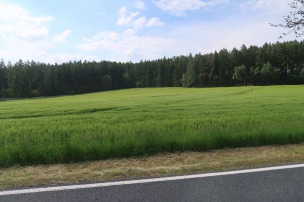
Once away from the cameras, we made far better time along Route 2. We were not really tearing around, of course, but travelling at the limit of ninety kilometres per hour, an easy lope where the biggish engine of our Heritage Softail feels eminently comfortable. The views over the countryside were lovely.


We soon came to the turning for Kouřim (Road 33320) and branched off north-east. This road was, as befits its five figure designation, a far narrower and twisty way and far less well surfaced. But it did wind through some fairly spectacular countryside with long, green views shimmering in the bright sun on what were some of the fairly precipitous descents.


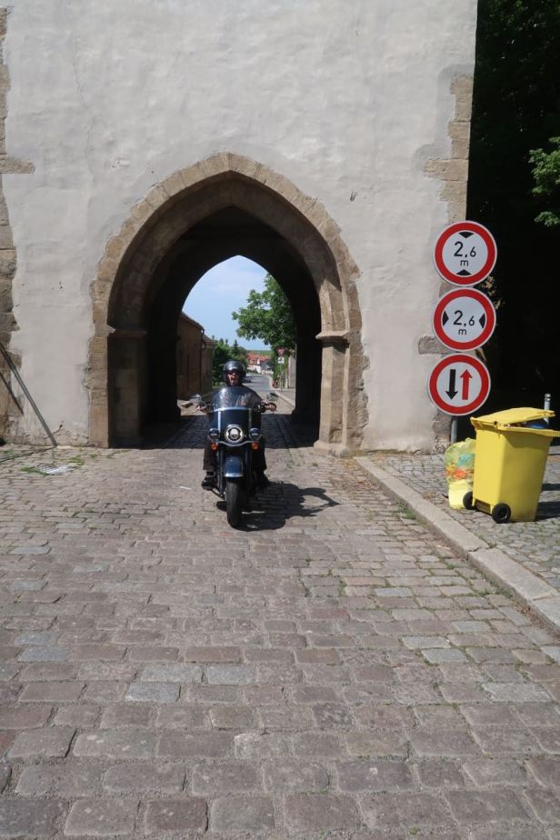
We soon came to Kouřim and, apparently, the SatNav decided that the main route into town was not scenic enough – and directed us through a maze of side streets so that we somehow approached the centre from the east ……

It is hard to really complain though because it directed us, with microscopic (or perhaps astronomic) precision, to a point right beside the little monument we had come to see.

This was nothing fancy, just a globe of shiny steel mesh, directly above a map of the Czech Republic with a pendulum hovering directly over Kouřim. This pendulum, we noted, had been helpfully welded into place to deter sceptics.
 Despite its “astrological” billing on the internet, a sign on the memorial made the “geographical” claim ….
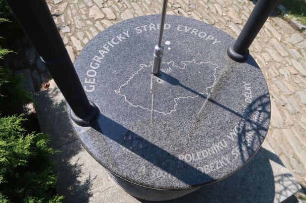
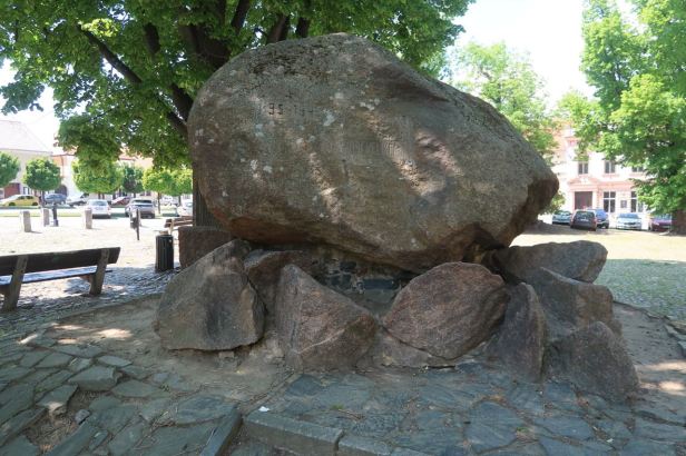
Nearby in the square was another monument, this one a huge boulder and is dedicated to Prokop Holý, the Hussite priest and military leader from Tábor who succeeded the military leader Jan Žižka. After a series of successful battles over a ten year campaign, Holý was defeated at the Battle of Lipany (not very far away from Kouřim) on May 30, 1434. The attached plaque bears the inscription “”Prokopu Velikému 1434-1934” (“Prokop the Great 1434-1934”). The monument was erected in 1934, the 500th anniversary of the Battle. Apparently, the epithet “Great” was as much to distinguish him from his namesake and contemporary Prokůpek (Prokup the Little) as an indicator of his prowess. (According to Lucie, the name Holý may be another epithet. It can be translated as “bald” because, unlike all the other priests at the time Prokup did not have a beard ! He did have a moustache, though).

Kouřim is obviously an ancient town and there was a church and separate bell tower nearby, but it was slightly shabby.


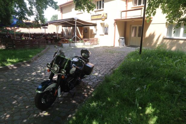
Just along the street was one of the original town gates through which we could have entered if the SatNav had not diverted us.

Close to the gate, quite literally next to it, was the restaurant, Restaurace Na Střelnici (Pražská 303, 281 61 Kouřim) to which we adjourned for our lunch. We sat outside, beneath some leafy Chestnut trees, quite literally in the shadow of the gate.
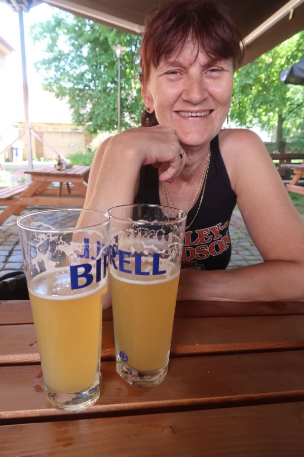
The lunch menu, in tune with ongoing restrictions, was a little bit limited. The service was prompt and we both had Smažený sýr s hranolkami a tatarskou omáčkou (Fried cheese with french fries and tartare sauce) which is a Czech classic and never disappoints.

To drink, we also both had a glass of Birrell alcohol-free beer with grapefruit. It may sound a bit strange, but this offering from the Radegast Brewery is very refreshing.
As we left, to “in your face” the SatNav, I rode out through the gate which it had denied us and then back through it again.

Now, with all due respect to the no-doubt worthy and well-intentioned Burghers of Kouřim, part of Lucie’s research revealed that the true point considered (by some) to be the centre of Europe lays not in the town itself, but around a kilometre and a half to the East. This is in the middle of some fields and obviously not so likely to draw in the curious (there were a surprising number of people coming to photograph the globe ..).
We took the road out of town towards Svojšice and crawled slowly along clutching my iPhone which has a GPS display. The central point is (supposedly) at 50.00.00N, 15.00.00E, which, to me, seems a little too “rounded” to be completely accurate, but what do I know. For reference, Wikipedia ™ mentions that there are about twenty other places in Europe which also claim to be its central point!! Anyway, we came to 15.00.00E and parked beside the road – but the northerly reading was slightly above the exact 50.

The field was planted with two crops, peas to the West and barley to the East, but naturally, the farmer was no respecter of the Meridian and the dividing line was not straight. Whilst we could walk in the peas without damaging them, a country-born lad like me was not going to trample the barley, By leaning out over the barley I was eventually able to get the display to read 50.00.00N but of course, this was accompanied by a longitudinal reading of 14.59.60E. To clarify, sixty seconds is the whole next minute – and sixty minutes is the whole next degree. I tried and tried, could not make it click over and I wondered if Steve Wozniak’s ears were burning !
We set off for Číhošť which the SatNav stated was about 40 kilometres away. The countryside was beautifully rural and unspoiled and the route selected electronically was scenic indeed. The narrow, winding, roads were not the greatest though and a little extra concentration was needed to avoid potholes and badly jointed repairs.

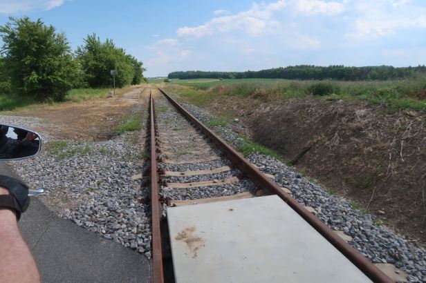
One curious thing was that, particularly at first, the road continuously crossed and recrossed the railway line. These crossings were ungated and that meant a modicum of caution needed to be employed each time we came to one.


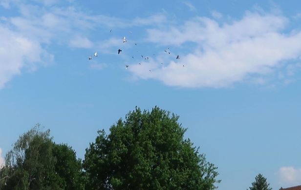
Numerous large raptors like Buzzards and Kites were to be seen slowly circling, high up in the very warm air. Lucie managed to spot a Kite being mobbed by smaller birds before beating a hasty and ignominious retreat.

The route which we followed was, I now know, not the most direct, but it was very picturesque. We cruised through endless green fields and small, quiet villages where olden-times architecture was prevalent in the churches and houses. We had no idea at all where we were, but I always say that, “with a SatNav, you may have no idea, at all, where you are, but you are never actually lost”. As we slowly drifted South and East, the landscape started to become more rugged and slightly hilly and we finally left Central Bohemia for the next region, Vysočina. The final part of our journey to Číhošť was through some lovely and, in the warm sunshine, very aromatic, forests of towering firs. These, in the Czech forests are mostly types of spruce and, sadly, these are dying in their thousands because of an aggressive beetle infestation.

I have to say that this is the kind of relaxed riding that we enjoy the most. Even when the road surface is not the greatest, it scarcely matters if you are just cruising and enjoying your surroundings.


We finally came into Číhošť and, thanks initially to an app on Lucie’s iPhone, soon found the signs leading to our destination.

We parked the Softail and walked down a marked grassy path between the houses.
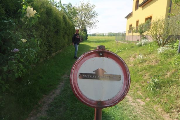
One of these houses had an elevated terrace looking directly at the site and a noisy family barbecue was taking place as we passed by. The site itself is well presented and well kept. An avenue of conifers lead you to and surround the site.

The first thing you see is a sign post. This indicated the direction of a number of major towns and cities gives the distance. We presumed this was the straight-line distance as it claimed that it was only 76 kilometres to Prague.

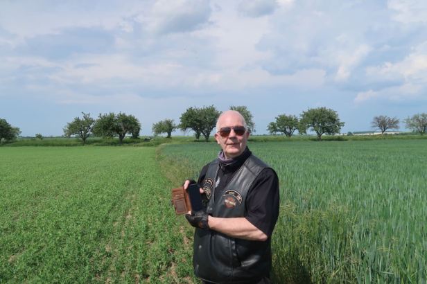
The monument itself is a large stone marker, which is oriented to the points of the compass.
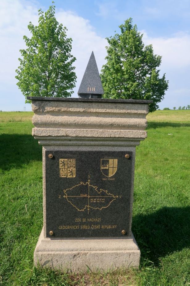

Beside the marker, a series of notice boards provide information and there is a roofed area with a table and benches. I wished we had brought some sandwiches. It was all pleasantly understated.
There was another biker at the site and we asked him to take a picture of us both by the stone, which he did – and then our camera battery died completely ! Like an idiot I had forgotten to charge it ! Luckily, it was quite a good picture …..
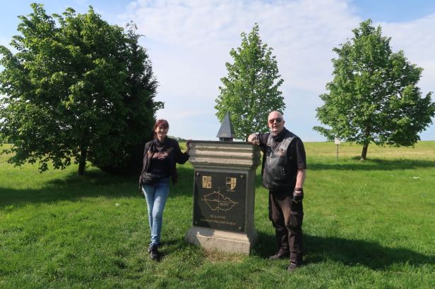
Lucie took another, of me, with her iPhone and that was really it. Mission accomplished, we walked back to the Harley.

Despite the sunshine, all afternoon, we had been vaguely aware of dark clouds on the horizon. Quite which horizon had been difficult to work out because, in the winding country lanes, our peripatetic progress had meant that, at some point, we had been riding in all directions. The alignment of the marker to the compass had put some very dark skies between us and Prague and there was the first suggestion, in the breeze, of that moister chill which can presage a storm. Handily, I did not even have my jacket. We decided to abandon our leisurely cruising and hit the motorway to try and get home before we got wet. That was more easily said than done because, even in those remote rural areas, significant road improvements were taking place – and improvement, in this instance, meant total closure of the road we wanted to take – and a lack of any indication as to an alternative. This lack of signposted detours is, sadly, quite common in this country. Lucie says this may date back to times when we were trying to confuse the invading enemy.Recalculate as it might, the SatNav was unable to come up with (what IT considered to be) a viable alternative, thus giving the lie to my earlier statement about not being lost ! In the end, we retraced our route all the way back to Číhošť and left the village by the way we had first entered it. I remembered seeing a sign pointing to Ledeč nad Sázavou, which I knew to be close to the D1/E50 motorway, at one of the turns we had made earlier and, when we got there again, we took it. The ride to Ledeč was uneventful and fairly swift as it was a wide, sweeping and well maintained road. Ledeč nad Sázavou seemed quite a pleasant town and is bisected by the broad Sázava river. Ordinarily, we might have lingered, but we could not, so we passed through the town and easily found the motorway entrance at Loket. This put us only about seventy-five kilometres from home – but it was still ominously dark ahead. Luckily, we never seemed to enter the rain ourselves. It was raining, away from the motorway, it was possible to tell from the clouds, but our journey was completely dry and we arrived home without feeling a drop.
More boxes ticked !

Somewhere else I can go to see !
It looks like a good ride !
LikeLike