Monday, May 8th, 2006 – Distance Travelled 230 miles

So, the last day of my trip along Route 66 dawned. Hesperia was quite high up above sea-level, so the air felt fresh and clean and there was good visibility all the way to a line of mountains in the distance. Just how high, or how far away they were was impossible to determine but, even in the heat of May, they appeared to have traces of snow on the tops of them.

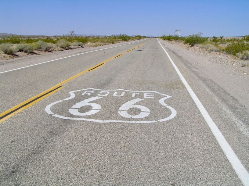
I paid my bill, rolled out of the Summit Inn and I set of down the I-15. Initially, I was unable to find, or maybe just to spot, any of the trusty little brown signs. Quite soon though, at a place called Cajon Junction, I did see a marker and I left the interstate for a far tinier and less significant road that not only had the usual brown signs but also, in one or two places, additional ones painted onto the blacktop, proudly stating it was the “Historic Route 66”.

From being in the lonely, unpopulated, middle of nowhere, I was now in what proved to be an endless urban conurbation. It was a little unnerving to be in so much traffic most of which seemed totally oblivious to the presence of a large motorcycle, even one with its headlight on. Lane discipline simply did not exist and it quickly became a little bit telling on the nerves.
As I entered San Bernardino, the way was blocked by a large excavation that had closed the road completely. My inner compass told me that the sea and, hence Santa Monica, must be to my west which was to my right. Needless to say the diversion forced me to go to my left, for block after block, before finally permitting me to at least turn south again. Ironically, this unplanned and unwanted traverse took me directly past the original McDonalds Restaurant (1398 N E St, San Bernardino, CA 92405). It was there, in 1948, that a milkshake salesman called Ray Kroc had one of those ideas that changed the way we live. Love it or hate it, McDonalds was a groundbreaker in a lot of things besides burgers. A sign, similar to the one in New York that calculates the National Debt of the USA, indicated the millions, if not billions of “Big Macs” that have now been sold. I think it might now be a museum as opposed to a burger bar, but I did not stop to find out.

Onward in the hellish traffic I went and was finally afforded the opportunity to turn west. As luck would have it, this somewhat serendipitously put me onto West 5th Street, in San Bernardino, which was also, according to the signs, Route 66 !
In such heavy traffic and with all the oblivious pedestrians, brain-dead drivers and other signage it was difficult to know whether I was still following the Route. I just kept going straight ahead, based on the assumption that was probably how they would have done it initially. Santa Monica did appear on a sign that led to wider, more freeway style, route called the 210, but just as I was about to take it, I spotted a small brown sign pointing a different way and was forced to join in with the general driving lunacy by double circling the interchange and diving off to my right.
On I went. Eventually, I found myself riding more or less underneath the 210, which meant I was going painfully slowly. I do not like the freeways, but I can understand how a city the size of Los Angeles simply must have them. Finally a tiny sign pointed me to the south, but then, almost immediately, west again and I trundled slowly along while, a few blocks away, everyone sped in the same direction, only a lot faster.
Finally, in the prosaically named “Old” Pasadena, another turn to the south put me onto the Route 110 which was also the old Route 66. At last, I was able to go fast enough, for a while at least, to cool the engine which was busily trying to cook me in places that I do not care to elaborate upon !
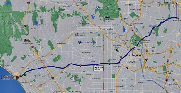
I followed the 110 for some distance but then the Route 66 signs did disappear completely. At the junction with Route 10, also billed as both the Santa Monica Freeway and the Christopher Columbus Trans Continental Highway, I stopped and scanned around for the signs I had been following since I had left Chicago. I could not see one and was flirting, quite seriously, with death simply by being stationary there. I finally gave it up and took the freeway. Of course, although this was four or five lanes wide in both directions, traffic was at a total standstill. I cautiously wended my way between cars wondering how anyone could stand to drive at all if that meant sitting like that everyday. It was moving, albeit at a snail’s pace and a good hiker would have left them all for dead. I came to a place where I could actually see the sea and, if I put my visor up, despite the petrol fumes I could smell the salty air as well. An exit sign indicated Olympic Boulevard. Despite my piteously inadequate research, I vaguely remembered that was where the Route ended. I took the exit ramp.
The number one rule of riding a motorcycle is that you can NEVER relax and I fear that, with the end in sight, that is what I did. As I rolled down the exit ramp, an SUV towing a trailer exited the freeway after me, overtook despite the fact that there was stopped traffic less than one hundred yards ahead – and nudged me, less than gently, with his trailer. Fortunately, the saddlebag took the brunt of that nudge, but for maybe two long seconds, I was not in control of the Harley. I suppose it was years of instinct that enabled me to right it, but there was no way that I was staying on the road which, luckily was bordered by a wide semi-circular concrete guttering about six inches deep. The straightened Harley dropped into the gutter and luckily the diameter of the trench was enough to allow for only a minimal folding of the footboards. I braked gently to a stop in the debris at the bottom. The SUV and trailer were no longer in sight. There was no way I was ever going to lift the heavy Harley out of the gutter, so I had no option but to roll to the very end where the waterway dropped into a grated drain and then gently ease myself back onto the tarmac. Only then did I really start to shake.
I pulled away towards the sea and found I was actually in Olympic Boulevard. The Route 66 End Marker was on the corner of Lincoln Boulevard, the very first cross street I came to (1670 Lincoln Blvd, Santa Monica, CA 90404). I had done it.
Santa Monica Pier was actually signposted, but along Lincoln Boulevard which I took to the next major road, Colorado Avenue, When I turned, it put the ocean right in front of me, less than half a mile away. I could see both the famous Ferris wheel and the Santa Monica Pier Arch (81-99 Colorado Ave, Santa Monica, CA 90401).

I rode down and parked as close to the sea as I could get. I descended onto the sand and walked to the edge of the ocean and dipped my boot in the sea. Then I climbed back up to the pier itself and bought an ice cream that was less than good. I was in a state of anti-climax. Years of thinking about it, about fifteen minutes of planning and now it was in the past. It had taken me only seven days on the road to get here and I still had twenty-two left. I wondered what to do.
For the record, according to the odometer on the Harley, I had at that point, travelled 2,746 miles. This was against the supposed distance, posted at the Mid-Point cafe of 2,278. Quite where the additional distance came from, I have no real idea. I had to get to the start from EagleRiders, I had made a few side trips (to Santa Fe, to the Petrified Forest, to the Painted Desert, the Meteor Crater, the Navajo village and, of course, riding backwards and forwards searching for the keys) but 470 miles did seem a bit excessive for those. Modern technology, OK then, Google, which did not really exist back then in the form it is today, quotes the length at 2,448 miles which would seem about right if you rode it exactly. That is, of course, very hard to do. It is difficult to locate at all in some places, as I found in Kansas and roadworks and diversions soon throw you off.
So, what to do next ?
At that time, I had a friend who, after living for some time in Prague had returned to the United States for the proverbial “family reasons”. He had served for some years in the U.S. Navy and, to the best of my knowledge, was living in a property he owned in the town of San Diego. I knew this to be about one hundred and fifty miles to the south, near the border with Mexico. Having had no idea how long it would take me to ride Route 66, I had not contacted him in advance of my trip. As I sat there wondering what to do next, I wondered if giving him a surprise visit might not be on the agenda. A mobile telephone is a wonderful thing so I pulled mine out of my pocket and I called him. He answered almost at once, but when I told him my plan, he laughed. At that very second he was sitting on the dock, not of the bay, but of his father’s home. That home was on the Northern Neck, which is a peninsular between the Potomac and Rappahannock rivers. Those watercourses are in Virginia and almost three thousand miles away !
He was however, intrigued by the fact that I was so close to his property in San Diego. He had moved back “out-east” because his aged father had become infirm and he had leased his own property. Part of the lease agreement had involved the fairly major trimming of some trees on the property and this had been done, that very week, at a cost exceeding $3500. He had the bill in his hands and asked if I would pop down and take a look before he paid it. Of course I agreed and we briefly suggested that, if I was at a loose end, I could come and visit him in Virginia. I said I might and a plan began to form in my head.

I returned to the Harley and took a leisurely ride north, all around the bay. I realised I was on the famous Highway One and followed it until it veered away from the coastline near Oxnard. On the way, I was able to take in the famous Palisades Beach and the “Will Rogers State Beach” (Route 66 is also called, in many places, the “Will Rogers Highway”) and Malibu. Because I really should have been heading south, I then retraced my steps and began to head back towards Santa Monica. I was feeling a bit listless, the way you do when you have just finished something and I stopped for an iced-coffee at a cafe that might have been owned by a distant relation, Perry’s Cafe 1200 (1200 Pacific Coast Hwy, Santa Monica, CA 90401). The Ferris wheel on the Santa Monica pier was clearly visible only about half a mile away. Everything felt so horribly normal that I could scarcely wait to get back on the Harley and get out of there. So I did not wait and, despite the superficial beauty of my location, I headed back to the Fat Boy and away I went.
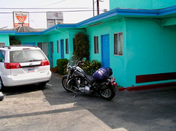
One thing I do like is having a goal, but it had somehow become late afternoon and it was clear to me that, although I could probably make it to San Diego before dark, I really did not feel like trying. I headed back to the freeway, which was still the Highway One and began to follow it. Here, still as Highway One, it began to head south a few blocks from the coast. It was still some form of expressway and certainly faster than the city streets, but it was awfully slow going. It seemed to almost cross LA-X airport before progress became a tiny bit faster but I realised that, despite the iced-coffee I had consumed, I was suddenly very tired. I spotted a motel, right beside the road, Manhattan Inn and Suites (3301 N Sepulveda Blvd, Manhattan Beach, CA 90266) so I just went and checked in, even though it was not long after five in the evening. I managed to get a room in the courtyard, away from the traffic noise and where I could park the Harley, motel style, right outside of my front door. The motel could, perhaps, be described as a tiny bit of a low-rent, but all I needed was a bed and a shower and it had both of those.
Freshened up, I decided that maybe I should eat something. I walked out to Sepulveda Boulevard and, away to the south, certainly less than half a mile away, I could see signs for various eating establishments. So I decided to stretch my legs and walk down to get something to eat. Now, bear in mind that this was on a warm, spring evening and I was on a wide road (it had what is called a median-strip) in a city. It is true there were not really any pedestrians, but it did not seem odd to me. About halfway along to where I was headed, I was quite startled by the whoop of a siren as a police car pulled to the kerb beside me with its lights flashing. I wondered what the problem was and, apparently, it was me. A policeman got out and asked me quite politely why I was walking there. My explanation that I was looking to get a pizza or something seemed to cut no ice and he then asked me how far away my car was parked. You know how it is, the immortal phrase “six thousand miles” was out of my mouth before I could stop it ! He was unimpressed and told me that it simply was not safe for “you” (I guess by “you“, he meant “me”, a lone white guy) to be walking there in South Los Angeles. All I could do was promise to be careful and it introduced a tiny frisson of concern where there had not, previously, been one, but what could I do ? I wandered down to an Italian restaurant, bought a pizza and wandered back to the motel far more watchfully than I would have liked. To give the police their due, the patrol car cruised slowly up and down the boulevard until I got back safely, so I did not feel threatened, but then I had not felt threatened before.
Back at my room, I ate the pizza whilst sitting on the saddle of the Harley before retiring for an early night. I remember, for the first time on the trip, putting on the security chain that was attached to the door.
