Sunday, May 7th, 2006 – Distance Travelled 576 miles
When I woke in the morning, I felt momentarily disoriented. As a Virgo, I like symmetry and the circular room certainly had it, but without corners there are few spatial reference points. Just an observation.
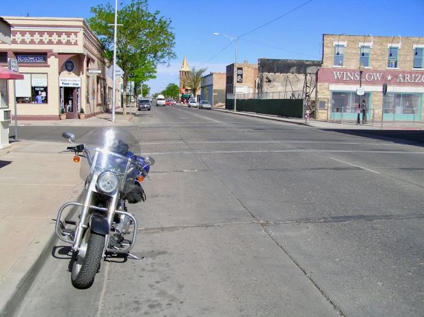
It was still fairly early so I though I may as well hit the road for what was to end up being, probably, the best day of the whole trip. I at least remembered to take a final picture of the Harley outside the wigwam which, although concrete, was very cleverly done. Then I dropped the key off in a reception area where there did not seem to be anybody anywhere and set off west with the early-morning sun on my back.

At this point, both the I-40 and Arizona Route 180 were “billed” as Route 66, which was probably unsurprising as they were only about 20 yards apart. In the interests of statistical authenticity, I chose the 180 and ambled along in the sunshine while far faster vehicles flashed by on the Interstate a few yards to my left. After about 30 miles of truly enjoyable riding, I do not really like to hurry and a Freeway/Interstate always seems to make me go a fraction faster than I really want to, I branched off and into Winslow.
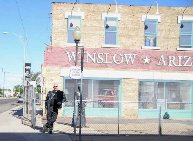
I often tell myself that I hate “kitsch” but give me half a chance and I unhesitatingly dive right in. Winslow, of course, does not rate a mention in the Route 66 song, but it does get one in “Take it easy” by the Eagles. That is why, I found myself “Standing on a corner in Winslow, Arizona”, a few minutes before seven-thirty on a sunny Sunday morning. This was another place where the local population fully realises what they are sitting on. There is a crossroads where that first line of the song adorns the building. There was no girl (my Lord) in a flat bed Ford to be seen but, in only a few seconds of me standing there, a lady in her Sunday best offered to record the moment for posterity and duly did.
Box ticked, move on.
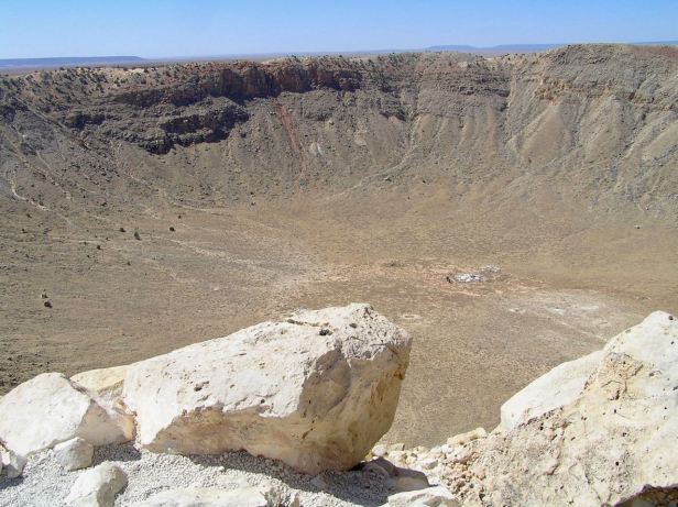
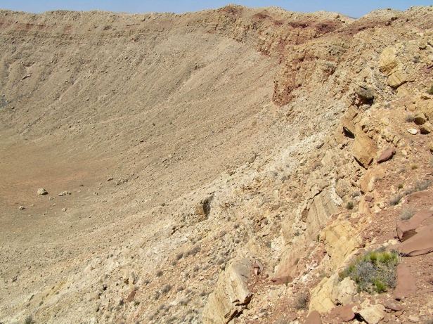
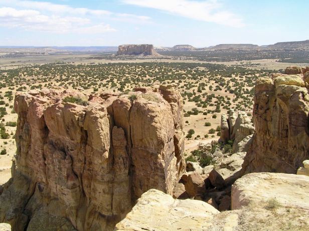
I left Winslow, still taking the Route 180 because it continued to parallel the I-40 and I was in no hurry. About 20 miles out of town, I saw a sign saying “Meteor Crater Natural Landmark”. I had not heard of this at all and I am a great lover of things that fall from the heavens. That said, had I been a resident of Winslow some 50,000 years ago, I might not have been so quite keen on that phenomenon. It seems a meteor, about 150 feet across and travelling between 29,000 and 45,000 miles an hour came screaming out of the sky and struck the (then far moister) ground with the force of about ten atomic bombs. The crater is well over half a mile wide and approaching, even now, six hundred feet deep. There is a rim of earth nearly one hundred and fifty feet high surrounding the crater that was thrown up by the impact and, although the comparative “newness” of this crater and the dryness of the climate means it is not very eroded, scientists estimate that winds have still reduced the height of this rim by fifty to sixty feet. The surface of the surrounding desert has a glassy look because a lot of it was literally melted by the heat of the impact. It is very impressive and, if you are ever nearby, you should definitely go and see it. Try not to think, as I did, about the possibility of a similar strike on a modern day city.


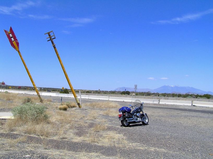
An unexpected, but breathtaking diversion behind me, I continued westward, still on Route 180. I soon came to a landmark I had heard about, the Twin Arrows Trading Post, or rather its ruins. This once iconic landmark fell into disuse when the Interstate was built and everything went speeding past instead of stopping. Two huge arrows with fading yellow shafts and crumbling red flights still stand in front of the decaying and much graffitied ruins of the post itself. Progress, eh ? I took a picture and moved on.


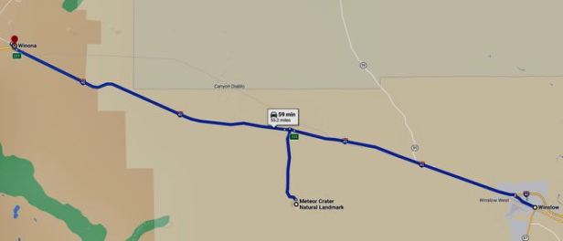
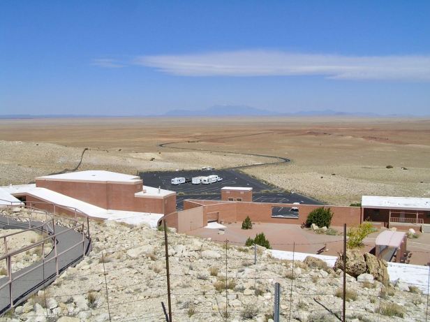
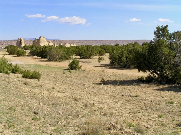
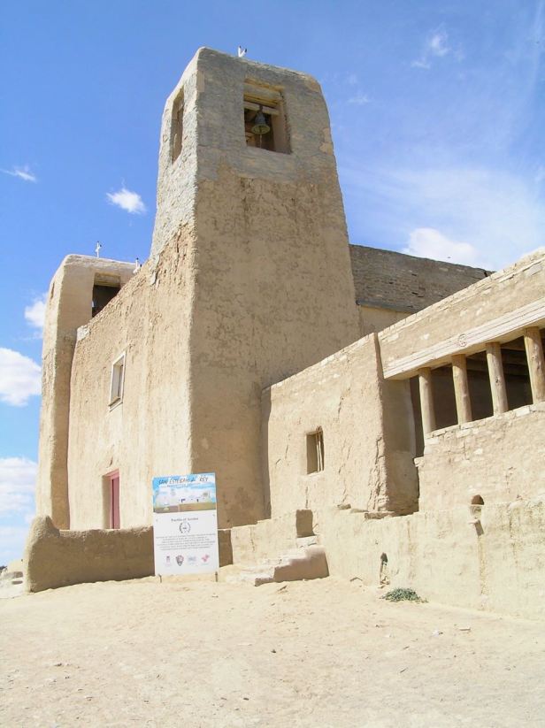
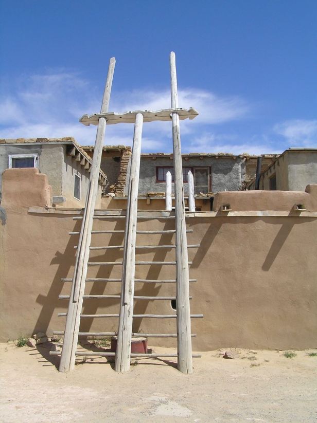
From the trading post, I followed the Route I80 to Winona (it is in the song and, as instructed, I did not forget it). I only saw the name on an exit sign though. I will say here that, in the lyrics, Winona (which rhymes, handily, with Arizona) appears after Flagstaff, so that the song scans better – but you actually come to it first. The original Route 66 is discontinued there (a sign says so) so it was back on the I-40 for me. As I approached Flagstaff (also in the song) the opportunity arose to rejoin the Route. As I left the Interstate, I saw a sign for Walnut Canyon National Monument, which, it informed me, was an ancient pueblo. I thought “Why not ?” and rode a few miles down what was little more than a dusty track and spent a happy half-hour poking about in some mud brick houses perched high above a canyon. Like the Roundhouses near the coasts in Scotland, the ground floors had no doors, presumably for defence purposes. Ingress could only be made on the first floor, which was reached by ladder which could be pulled up.


Back on Route 40 which proclaimed itself to be Route 66 (it really is a bit confusing all the way along) I entered Flagstaff. In honour of its place in the song, I stopped for a breakfast of bacon, eggs and all kinds of other largely unnecessary stuff at the Galaxy Diner (931 W Rte 66, Flagstaff, AZ 86001) because it was right on the Route. It was a bit like being transported back to the 1950s, it had that kind of “feel” and the menus were all circular like 78 and LP records of my youth. There was an astonishing variety of milkshakes and my delicious chocolate one was quite probably “groovy !”.

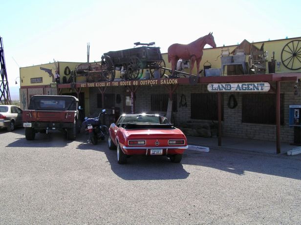
I left Flagstaff on the I-40 but about two thirds of the way to my next port of call which was the town of Seligman, a familiar small brown sign pointed off to the right and I followed the “old road” for quite some distance well away from the Interstate. This enabled me to have two further drinks, which I confess were Coca-Cola, at two other landmark sites. The first was the charming “Oh ! I have suddenly been transported back to the 1940s”) Hackberry Stores (11255 AZ-66, Kingman, AZ 86411) and then, as I entered Kingman, at the Outpost Saloon (9321 E Highway 66, Kingman, AZ 86401).
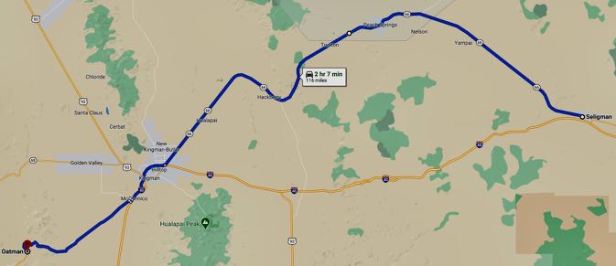
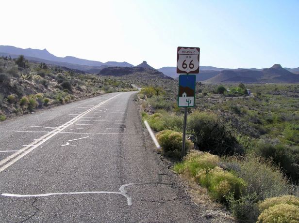
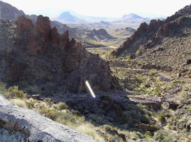
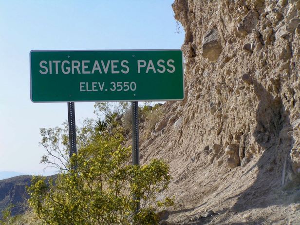
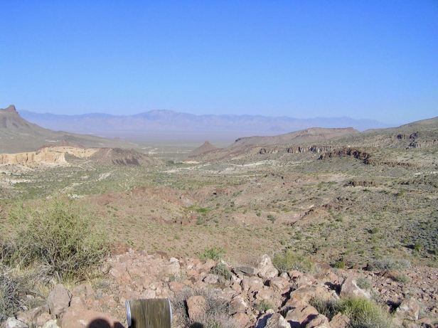
In the song it may be, but Kingman, had little to encourage me to hang around. As I left, the little brown signs directed me south and handily avoided the I-40. At the town of McConico, only a few short miles down the road, my way looped over the I-40 and, almost immediately, the main road turned south again down Arizona Route 10, towards Oatman, which was not marked as Route 66. I was then riding through the kind of scenery most usually seen in a cowboy film. Flat, scrubby land with low desiccated bushes stretched out on both sides as far as the eye could see. Ahead were mountains of the sort that it take ages to get any nearer to. But eventually, I did get to them and the road snaked sinuously through what I now know was the Sitgreaves Pass. Again, it was straight out of a western movie. A narrow, twisty road, often affording very little in terms of forward vision and with a precipitous drop on one side, usually directly under my right elbow. To describe it as awe inspiring might be to under report it. Standing at the top, looking back the way I had just come, is another one of those things that will stay with me forever. That was why I was here.


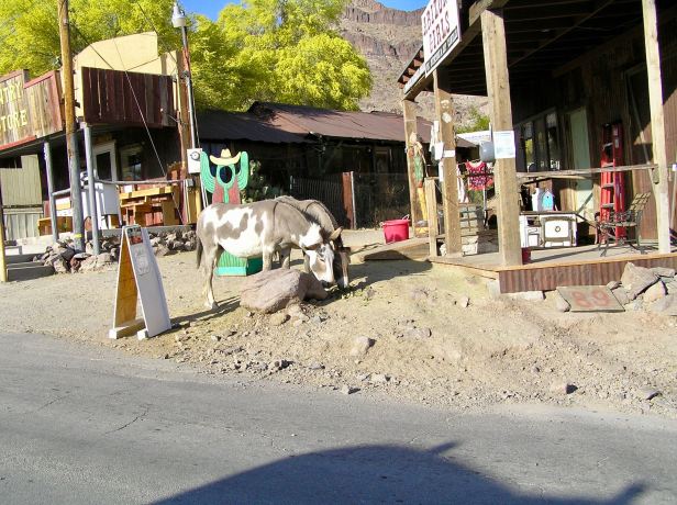
Oatman itself only served to reinforce the cowboy theme. The whole place looked like one of those one-horse towns from a John Ford movie – except with countless cars. The town obviously plays heavily on this “Old West” motif and is clearly, judging from the number of people around who seemed to be from the 1860s, some kind of cowboy tourist mecca. There were lots of mules wandering, apparently wild, in the streets. Just passing through required more than a modicum of caution so as not to reduce their number or hit some big American car also seeking to avoid doing that. It must be fun at night.

I rolled straight through Oatman and back on down Route 10. I was quite soon confronted with a choice, neither of which involved Route 66. The road forked and Route 10 went to the left, so I took it. This was grand and beautiful country indeed with dark mountains to my left and the road undulating at their feet towards the dusty horizon.
I now admit to a mistake. When I had picked up the Harley, I had been informed that its range was around 150 miles on a tank of gas. I had religiously filled up at around 130 miles, particularly as I had already encountered a few very lonely stretches of road. Sadly, so entranced had I been by the scenery through which I was passing and then so keen to quickly quit the equine hubbub of Oatman, that I had forgotten to do it. I now noted, with mild alarm, that I had already passed 173 miles and I could see no sign of any habitation on the horizon. I stopped, shut off the engine (obviously) and considered my position. I was about ten miles out of Oatman and the way from there had been predominantly downhill. Which meant that to turn around and go back, would be mostly uphill. Of course, I had no map and, even if I could have got a signal on my ‘phone (which was quite rare in those parts at that time) there were no map apps in those days. I racked my brain for a memory of a distance shown on a road sign and clutched at the thought that some town whose name I could not recall was 17 miles from where I had turned. It was the classic dilemma. I was pretty much, if my memory was correct, at the mid-point. Ahead was downhill, so I gingerly restarted and went ahead. Obviously, I was going quite slowly, rolling down inclines with the clutch pulled in and riding up the other side with only the minimum required power. The horizon stubbornly refused to come any nearer and the total absence of any other traffic, in either direction, made me wonder just how long I would be sitting beside the road before I could get help. The majestic scenery now seemed a bit threatening. The odometer ticked up 180 miles. In the far distance, something glinted. I pressed on. Every mile seemed to take an eternity and in my mind, the Fat Boy was sucking on fumes. I finally came to the source of the glint, but it turned out to be a big, upmarket housing development, called Golden Shores and it was plainly obvious that there was no gas station. I clutched eagerly at the thought that all those gas-guzzling big cars and SUVs I could see parked had to have somewhere to tank up and, about a mile later, at a similar development called Topock, I at last saw a Shell sign. I filled the tank up, with a huge sigh of relief, at 188 miles, noting as I did so, that it was not as empty as my fears had imagined it to be. Phew !
Two or three miles later, I came to the junction with the I-40, which had looped around the other side of the mountains and I turned right towards Needles. Almost as I did so, I crossed the Colorado River and entered the eighth and last State through which Route 66 passes, California.

I soon came to Needles, it was not too inspiring and I chuckled to myself that I managed to drive through it without encountering Snoopy’s itinerant brother Spike. I was also sure there were some biblical jokes about camels to be made as I passed through it, but there was nobody to make them to. It was fairly hot and the streets were deserted.
Not far outside of Needles, U.S. Route 95 branched off to the right with a little brown arrow for Route 66. I took it and, about five miles later, in Arrowhead Junction, it was actually signposted, because it was it, as Route 66. Nothing else, which was rare up to that point, just Route 66. The road looped around, eventually passing under the I-40 and then circled to the south of it. Straight after it went under the interstate, it did become very narrow and poorly surfaced. It was passable, but only with great care. Fortunately, after about five miles, it became a far better road when it was joined a larger one. The new road was coming from the I-40 a few miles to the east and was not numbered, but described as the “National Trails Highway”. Luckily, it also “became” Route 66 at that point too.
This was the Mojave Desert, big time. It was very hot and dusty and, as ever, in such places, the road just stretched ahead until it vanished into a point on the horizon.

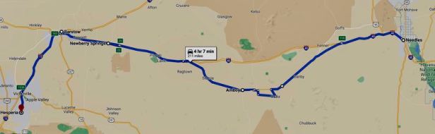
It really was baking and so when, in the town of Amboy, I spotted another “site”, Roy’s Cafe (87520 National Trails Hwy, Amboy, CA 92304), I simply had to stop for a cooling drink. In truth, to call Amboy a town is to aggrandise it a bit, there really is not anything there. A few buildings straddle a very long, very straight road and it was totally deserted. I sat inside and helped myself to a rather pleasant iced-coffee. It felt really good to be out of the heat.

Then, another piece of good fortune.
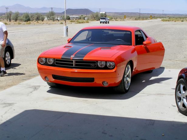
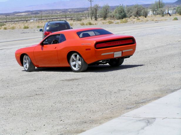
When I came back outside outside, a covered semi-truck had pulled up on the wide hard shoulder about a quarter of a mile down the road. Some men were struggling with a ramp of some kind and I might have ignored them had it not been for the sudden roar of what was obviously a seriously powerful engine. As I watched, a large bright orange car slowly reversed down the ramp and onto the gravel. That was the engine I could hear. This all seemed a little bit curious so, what was I to do but amble over to take a look. It turned out that what I was looking at was the factory prototype of the (then) new Dodge Challenger. Chrysler was planning to release it to the general public as an updated version of their car that had won fame at Le Mans and as “The General Lee” in TV’s “The Dukes of Hazzard”. One of the drivers told me that the car I was looking at had cost eleven million dollars to develop and some other guy with a clipboard actively tried to stop me taking pictures of it. But I did. It certainly accelerated in a truly startling fashion. It was a big car, but it became a small orange dot in a matter of seconds and left an awful lot of rubber on the road. As I rode away west, it appeared ahead and came flashing towards me, passed me in a blurry orange roar and disappeared into a speck in my mirrors in about half the time it took to write that description.
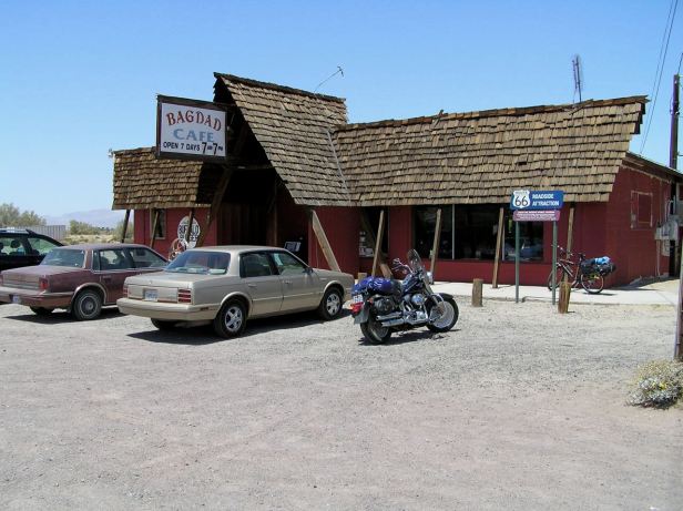
Hardly had I started again than I came to where I half expected to find another site, the equally insignificant town of Bagdad. I had once seen a film called “Bagdad Cafe” that had been set in the Mojave Desert. Bagdad appeared to be almost a ghost town and look as I might, I could not see a cafe (and in such a tiny, decrepit place it could not really have been hidden). Ah well, move on !
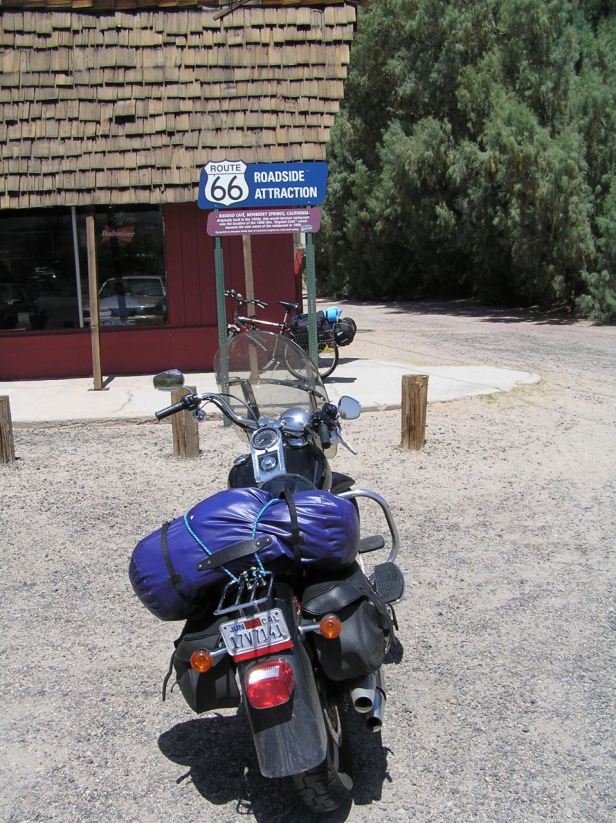
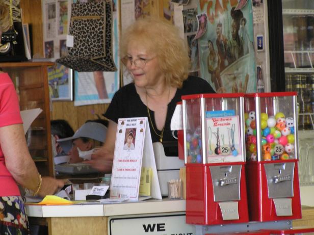
Still in the sweltering heat, I soon passed through a small town called Siberia which, you can be certain, caused me a wry smile. The way came to the I-40 again, but helpfully paralleled it, so my National Trails Highway/Route 66 ride continued. Somewhat confusingly, in the little town of Newberry Springs, some fifty miles from Bagdad, what should I see beside the road but the Bagdad Cafe (46548 National Trails Hwy, Newberry Springs, California, 92365). It only served to reinforce the old adage ”do not believe what you see in the movies”. It was definitely the place from the film however and what could I do but enter and buy something ? I took another iced-coffee, something I was becoming increasingly fond of and the lady behind the counter was so warm and welcoming that I also bought a commemorative T-shirt, which I still have at time of writing.

I soon came to Barstow. It is in the song but I did not stop as I had spent far too much time dithering about. A bit of helpful brown signposting helped me to avoid the I-15 and to find the continuation of the National Trails Highway/Route 66 combo that had served me so well. I followed the old Route all the way to Victorville where the signage seemingly evaporated.
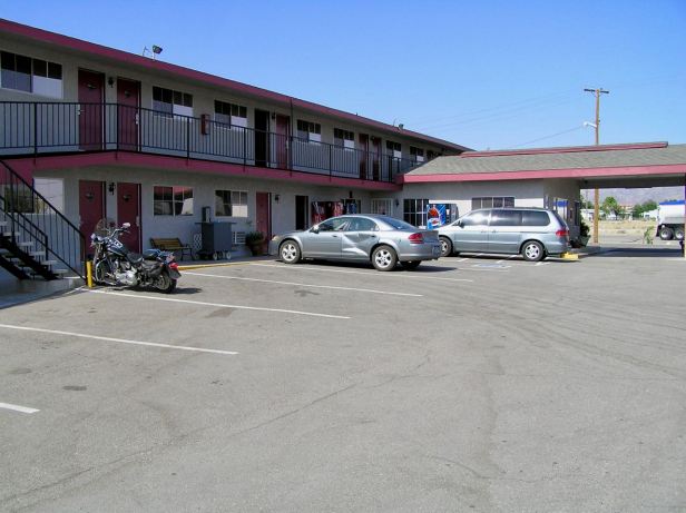
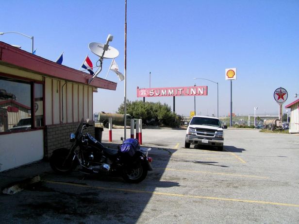
I was obliged to revert to the I-15 upon which Los Angeles was now clearly signposted. Evening was coming on and, as I climbed out of the next part of the conurbation, that was apparently called Hesperia, I spotted a motel sign, high up beside the road and decided to call it a day. I negotiated a rather complicated cloverleaf junction and soon checked in at the Summit Inn, (Hesperia, CA 92344). There appeared to be no places to eat within easy walking distance and, having come nearly six hundred miles I was not keen to go riding around in the dark. I know I used the Inn’s diner, but due to later events, I have no note of whatever it was that I ate.
My room was comfortable though. As I drew my curtains, Los Angeles announced its proximity with a distant glow in the sky. In the few seconds that elapsed between turning out the light and going to sleep I realised that the following day I would come to the end of Route 66 – and I still had three weeks of my holiday left !
