
Saturday, May 27th, 2006 – Distance Travelled 287 miles
I needed to be up early and that was easy. I did set the alarm on my ‘phone, but I did not need it and I was already showered when it started buzzing at six a.m. I ventured outside into a warm morning that, although the sun was not fully up, was already promising a hot day ahead and set off south towards Washington DC. Well, not south, exactly, I first went west on Routes 132 and 22 until I came to my old travelling companion the I-95, then I did turn south. I noted that, at that point, the I-95 was called the “John F. Kennedy Memorial Highway“.
When the time came to cross Baltimore Harbour, I kept to the I-95 instead of taking the arguably more direct I-895, because I wanted to see something. The I-95 bridge over the harbour gives a southbound driver a fine view of Fort McHenry. The fort’s survival of shelling by the British in September 1814, during “The War of 1812”, inspired Francis Scott Key to pen “The Star Spangled Banner”. A large flag, fluttering on a tall pole, was certainly visible in the dawn’s early light, but as I had previously seen the tattered original in the Smithsonian Institute in Washington DC, I passed on by.
According to my directions, I needed to approach Alexandria down the eastern side of Washington DC so, when the signs offered it, I took Route 295 southbound. It was still relatively uncluttered, but what drivers there were tended to be where they wanted to be on the road. Lane discipline is practically unknown in America and I passed and was passed by vehicles on all sides. I crossed into The District of Columbia, not a state as such, but clearly defined, none the less. The 295, which became the I-295 at about the same place where the Anacostia River, that was to my right for much of the journey south, joined the larger Potomac. I crossed back into Maryland, joined the I-495 westward across the Woodrow Wilson Bridge (a popular guy back in Prague, is Woodrow) and passed momentarily through DC before leaving the bridge into Virginia. I guess there must be a point somewhere there where you could be in three places at once, but I did not look for it. Alexandria was now directly to my right, so I took the first exit, onto St Patrick’s Street, as I had been instructed.
Then it all went a little bit pear-shaped, but I did get a “moment” out of it. At a turning I had been instructed to make, I could not turn because it was obstructed by an “official” looking barrier (the saw-horse things you see on police movies). The same was true at the next-but one (it had the alternate one-way thing going on) and possibly the next six or seven opportunities were also denied me. Finally, I was able to turn and go across the few avenues to the one I wanted. There was no visible sign, anywhere, of why all the other streets had been blocked, but I digress. Of course I was way too far north, in the 1800s (eighteenth block) when I wanted the 100s (first block). I set off south, thinking how wonderful the American system could be. But, at the end of the 300 block, the avenue ended on a T at a cross street. Now, I know that Americans can be contrary, but they are also ferociously logical. I surmised that the avenue must continue behind the gardens in front of me and so I turned right and then first left. This led me into a narrow street and I do mean narrow. It was just over three cars wide with vehicles parked on both sides and heavily potholed. Trying to avoid the holes, I proceeded down it very slowly, hoping to see a way off to my left. A big SUV came speeding down the road and appeared in my mirrors. The road must not have been as narrow as it appeared as it sped up behind me. It was huge and pearly white with heavily tinted windows and I could hear its big V8 rumbling at what seemed about a mere eighteen inches behind my ears. The proximity of the SUV and my constant scanning for an approaching left turn was a bit distracting and the Harley wobbled as it dropped into some of the holes. I wanted to pull over, but there was no space to move into. It is amazing how long a few hundred yards can be in such a scenario and, finally, I spotted a small space and drove into it. The behemoth rumbled halfway past and stopped. I heard the door open on the far side and a huge black guy walked around the front. This was a Gangsta in cliché form. Bald head, thick gold chains and rings, snowy white tank top and mirror shades. Sorry for my pre-conceived prejudices, people, but I had heard about Washington and I thought I was probably about to die. Of course, when the giant spoke, his voice and demeanour did not go, at all, with his look. He asked me if I was lost, found out where I needed to be and gave me a clear explanation of how to get there. Then he got back in the SUV, it was a Ford Expedition (if you care) and rumbled off with me now following him. When we came to where I did need to go left, he slowed, pointed and the then raised a thumb before driving away. I was at my friend’s house five minutes later (and ten minutes early). We live and we learn.
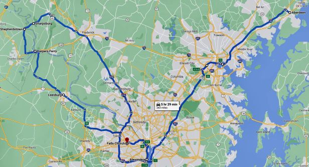
My friend knows very well what I like and, with the foreknowledge that I wanted to visit Sharpsburg, had planned a route of various other Civil War oriented sites. We left Alexandria and found the I-495 which I had arrived on. This is also the “Capital Beltway” so we followed it west and then north for some distance before turning west again onto Route 267. This took us through the suburbs and, once we had circumnavigated the surprising mayhem around Dulles Airport (it was a holiday weekend, a fact which I was previously unaware of), out into the green countryside of northern Virginia. Eventually, after a few minutes on what seemed to be both Route 7 and Route 15, we entered the town of Leesburg. It was a bit cutesy, one of those places that is historic and wants to throw that fact in your face a bit. The crowds were a bit disconcerting so we passed slowly by the house of Robert E. Lee’s grandfather, took a cursory glance at the Ball’s Bluff battlefield site and moved on. Our next destination was Harper’s Ferry. This was the scene of John Brown’s raid, in 1859, on the Federal Arsenal there. The raid was one of the key events that, eventually, precipitated the American Civil War.
We left Leesburg on Route 7, which became Route 9 and then at Mechanicsville, the site of another savage Civil War battle, we switched to Route 671. Not for the first time, I was struck by the “up close and personal” aspects of the Civil War. We were still so very close to Washington. To try and put it in context, it would have been a bit like trying to defend London by fighting the enemy on the runways at Gatwick Airport.
Route 671 ran straight to the banks of the Potomac River, but, instead of crossing it, we forked left onto Route 340 and crossed into, of all places, West Virginia. If you are thinking I had not seen that one coming, you are correct ! We did then cross a river, but this was the fabled Shenandoah which flows into the Potomac at that point. The town of Harper’s Ferry lay directly on the other side, at the confluence point of the two watercourses. It was another place very full of itself on the back of the historical accident that had brought it to prominence – and another place literally teeming with people. We drove slowly past the Firehouse where Brown had holed up before being captured and executed, the crowds meant there was no chance of going in. I did stop, but only to stand upon the same ground as Robert E. Lee, Thomas “Stonewall” Jackson and the cavalry genius, Jeb Stuart. All those later stalwarts of the Confederacy were then serving in the Union army, as was a then unknown soldier called John Wilkes-Booth who attended Brown’s execution and was later to assassinate Abraham Lincoln. As for John Brown, martyr or murderer, read him up and you decide. Nonetheless, historic ground indeed.
We left Harper’s Ferry in a westward direction on Route 340, before turning north at Halltown onto Route 230. This led us through some rolling and wooded countryside to Shepherdstown where we crossed the Potomac and back into Maryland on Route 34. Soon, like the forces of Robert E. Lee, on the morning of September 15th, 1862, we rolled slowly into Sharpsburg. It was a quiet and peaceful little place and, away from the inevitable modernisations that have taken place in the town itself, I doubted it looked very different from how it did during all of the unspeakable carnage of the battle.
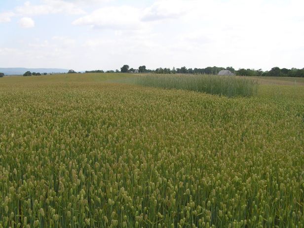
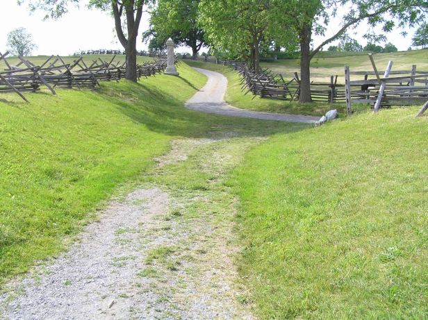
I found the battlefield strangely effecting. That might sound strange after all of the previous visits I had already made to other places where similar events had occurred, but it is true. When I was quite young, I saw a series of pictures, produced by an early photographer, Matthew Brady. Included in these were a number of the aftermath of Sharpsburg. Like all battles, there was a lot going on everywhere. In one thirty acre cornfield, close to six hundred corpses from both sides, were strewn in grisly rows. Even a grainy black and white photo could distinguish the differing shades of their uniforms.
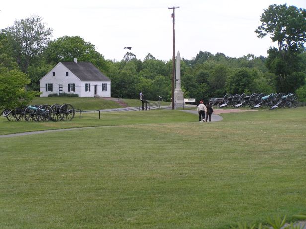
Behind them in the photos, hinting at the bucolic peace of only days before, stood a boxy, white-painted church of the Dunker religious sect. The same church is still there today.
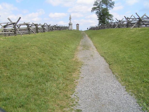
A short distance further south, is the infamous “Sunken Road” where Confederate troops lay in the shallow depression caused by wheeled traffic and repelled wave after wave of Union assaults. By the time they were finally overwhelmed and driven back, they had left well over five hundred of their foes dead. Apart from a monument, the road, flanked by a rail fence, looks almost exactly as it did in Brady’s pictures. The scores of bodies, images of which are said to have shocked America, are gone – but otherwise the photo could have been taken the previous day.
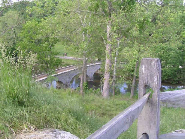
Finally, even further to the south, but given the small scale of the battlefield, that was not very far, lay the Lower (now christened “Burnside’s”) Bridge. Union forces trying an outflanking movement attempted to cross this narrow span, but could only do so about five abreast. A handful of Georgian sharpshooters prevented them from doing so for hours by simply picking them off at each attempt. I could go on and on.


Despite overwhelming numerical superiority and the good fortune of capturing a map of General Lee’s dispositions, the Union commander, General McLellan was timid and, ultimately, he allowed Lee’s forces to slip away back into the Shenandoah Valley. It was later said that more decisive action, by McLellan, could have ended the war there and then. Although longer battles did surpass these grim figures, the total casualty count of almost four thousand deaths and over eighteen thousand wounded makes Sharpsburg (or Antietam, in Union parlance) the bloodiest single day in American history.
There is a high observation tower, from which the whole layout of the entire battlefield can be seen. Such a lot of death and injury in so small an area.

Sensing my sombre mood, my companion contented herself with a bit of reading in the sun while I walked around. As ever, it was hard to reconcile the quiet beauty of the landscape with the knowledge of what had happened there.
We rode back into Sharpsburg where (her) prior research led us to the famous Nutter’s ice-cream emporium (100 E Main St, Sharpsburg, MD 21782). Goodness me, it was good. My mood lifted at once – but, as I have remarked more than once, that is what half a pound of sugar entering your bloodstream will do for you !

In the late afternoon sun, we left the town on the northbound Route 34 and then switched to the enigmatically named ALT Route 40 which blended into Interstate 70 as far as Frederick. There we took the I-270 all the way back to the fringes of Washington DC, where it became the I-495 to cross the Potomac. I had ridden a lot of the same route, albeit in the opposite direction, only five days before, but it already seemed like about two hundred years in the past.
Local knowledge always wins out and, after we crossed the river I was guided to Route 123 which is the George Washington Memorial Parkway. This ran along the south bank of the Potomac and was rather pretty. By following expertly given instructions, I was able to loop off of the Parkway, circle the Iwo Jima Memorial outside of Arlington Cemetery (Arlington was Robert E. Lee’s mansion, chosen as a cemetery to prevent him ever moving back in) before crossing the Theodore Roosevelt Bridge (on the I-66) and wending our way past most of Washington DC’s major sites (the Lincoln Memorial, the White House, the Smithsonian Institute, the Capitol Building). Then we joined the I-395 to recross the Potomac, divided there by an island, on the Arland J. Williams (I wonder who he was !) Bridge before swinging south again, in the very shadow of the Pentagon, back onto the Parkway. This was not so picturesque at this point and flanked the Ronald Reagan Airport, but it led us straight into Alexandria where my friend located her house with none of the difficulties I had experienced in the morning.
We drank a couple of cups of coffee and parted as we always did with promises to keep in touch. My companion works for the State Department in the area of refugee assistance and this leads her into some fairly dodgy locales. She has been sniped at in Albania, had her armoured Chevrolet Suburban blown up by a Serbian landmine (while she was in it) in Kosovo and returned to an office that had been destroyed by a bomb in Iraq. How dull my existence must have seemed to her.
I left Alexandria on Route 7, to which I had been directed because it ran directly to where I was going. I easily located the house of another friend, in Falls Church, despite the onset of darkness. This guy has a Czech wife who still has family in Prague, so we see each other regularly anyway. So, no real catch up was needed and we were rapidly into beers, burgers and chatting about English football, of which he is a huge devotee. It was soon bedtime and I collapsed exhausted onto my bed and quickly drifted off sleep to the comforting hum of an air-conditioning unit.
